Climatology: 2024 Summer IDEC Internship Experience
By Sienna Ecker, Increasing Diversity in Environmental Careers Fellow – Placement: DNR: EWR: Climate Office Student Worker
The Minnesota State Climatology Office, located on the UMN St. Paul campus, is a treasure trove of weather paraphernalia, historical documentation of extreme weather events, and, most importantly, some of the best climate resources in the state. I joined the office shortly after graduating from the University of Minnesota with a degree in Geography. I wanted to apply some of the skills that I learned to real-world scenarios. With the ultimate goal of deepening my understanding of Minnesota’s geospatial climate patterns and future climate outlook.
I would describe this summer as a computer fluency boot camp, you’d be shocked just how much data about weather exists out there. While numerical data is helpful, it doesn’t appear to mean much without a visualization of that data. That’s where ArcGISPro and Excel come in handy. Given that I am a geography major, I think it goes without saying that I am quite fond of maps. In my role at the climate office, I was able to use my knowledge of ArcGIS to create maps reflecting some pretty cool weather data.
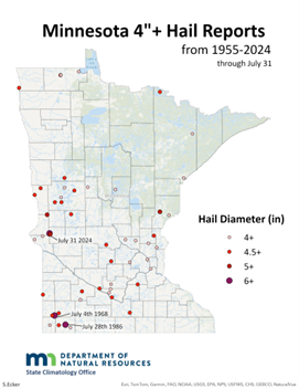
Summer 2024 was notably wet, characterized by cooler temperatures and frequent precipitation events. This summer also set new records for hail size, with one of the largest hail events in Minnesota’s history, (Giant Hail, Heavy Rain, Strong Winds, July 31 to August 1, 2024 | Minnesota DNR) —and yes, I made a map about this.
This wave of precipitation events is crucial as it highlights potential weaknesses in our public infrastructure. With climate change, heavy precipitation events are becoming more frequent, outpacing Minnesota ecosystems’ ability to adapt. This makes it our responsibility to protect ecosystems, communities, infrastructure, and water quality. (FYI… CCMI is helping address this concern with the installation of rain gardens, this is a great example of a sustainable practice that can help mitigate the effects of stormwater runoff!) In the face of flash flooding, we must ensure that our most vulnerable communities are safeguarded. Geospatial representations of these impacts provide a nuanced understanding of the affected areas and populations.
During my time at the Climatology Office, I’ve developed several tools to deepen our understanding of these geographic and statewide threats. One of these is a series of maps that offer a periodic record of normal (50-year) temperature values across the state. These maps include monthly variations of average maximum, minimum, and mean temperatures. These maps help visualize contour lines influenced by shifts in temperature, providing a clearer understanding of how different areas of the state may be impacted by a changing climate.
I’d encourage you to check this link out, if you are interested in GIS there’s a downloadable gdb file where you can create your own version using the data!
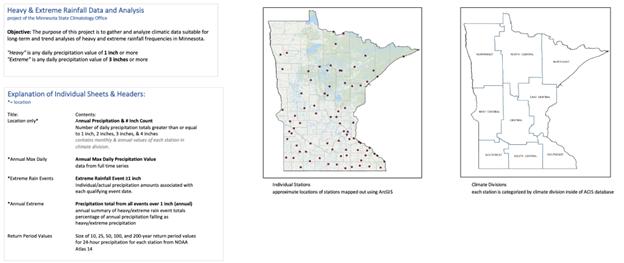
A last highlight I want to share from my experience was the extreme precipitation database I created. This was a lot of work and is responsible for deepening my comprehension of Microsoft Excel. The database consists of a full-time series of approx~ 80 stations. Here’s the explanation page to cover the gist of it.
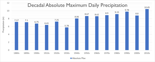
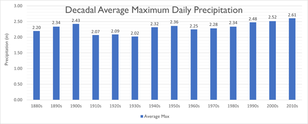
Just for fun here are a few graphs illustrating some of that data 😀
Why is diversity in this area of natural resources important?
Diversity in natural resources is crucial. Extreme weather and climate change don’t discriminate; they affect everyone. To fully understand and address these challenges, it’s essential to represent all communities, cultures, and individuals. At present, the Climate Office is a small, dedicated team of three. While they are great at what they do, the evolving climate crisis demands a broader range of perspectives. By expanding the emphasis on climate, we can tackle a wider scope of projects, address diverse objectives, and better protect Minnesota’s resources for the future.