When It Rains, It Pours
By Kyle Dahlquist, Clean Water Corpsmember / AmeriCorps Member placed at Pennington SWCD
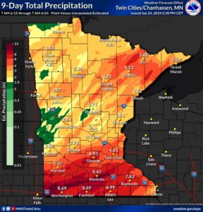
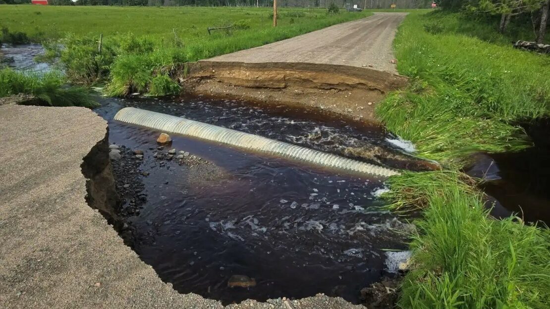
If you’ve been outside at all in the last few months, you may have noticed that Minnesota has been…soggy. The entire state has seen significantly above average rainfall from April until the start of July, setting a state record for this three-month period. This made up for the year’s relatively dry winter, and relieved much of the state from drought conditions. It wasn’t all good news, however, as the unrelenting precipitation caused a number of rivers to swell and flood across the state. Of particular note is a series of storms that pounded Minnesota from June 15th to the 22nd. Rainfall totals varied from four to eight inches across much of the state, with some locations in southern Minnesota enduring an eye-popping eleven inches.
The damage was most pronounced in the northeastern and southern regions of the state. The cities of Virginia, Cook, and Ely were among several places under threat in St. Louis County. The Boundary Waters Canoe Area (BWCA) in the Superior National Forest was temporarily inaccessible due to road washouts, and visitors to the BWCA were advised to exercise caution due to the dangerously high and fast waters in the region.
Southern Minnesota fared no better. The June deluge triggered flood warnings for the Minnesota, Des Moines, Crow, Cottonwood, and Mississippi Rivers. Several major highways connecting Mankato and the surrounding area closed. Valleyfair, an amusement park in Shakopee, was forced to close several attractions due to its proximity to the overtopped Minnesota River. Fort Snelling State Park remains closed, as flood warnings remain in effect for the last stretch of the river. Minnesota’s flooding was so severe that federal disaster assistance was approved on July 1st to assist in relief efforts.
While certainly impressive, just how does this year’s precipitation compare to other significant rain events in Minnesota’s history? According to the DNR, Minnesota has had 21 so-called “Mega-rain” events. These events are defined as a 24-hour period in which six inches of rain falls over an area of at least 1,000 square miles. These storms often caused catastrophic flooding, and have been increasing in frequency since the year 2000.
While not quite reaching the status of these “Mega-rains,” this spring’s sustained battering has done a number on transportation infrastructure and agricultural production all over the state. We’re roughly halfway through the year, and it remains to be seen if 2024 will surpass the 1977 state-average precipitation record of 33.92 inches. In the meantime, stay dry and keep your eyes on the sky!
Sources
Historic mega-rain events in Minnesota (MN DNR)
An Extremely Wet Period in Minnesota (MN DNR)
Flood cleanup continues in northeast Minnesota. Rivers still rising across the state (MPR)
Minnesota hits a state rainfall record (MPR)
President Joseph R. Biden, Jr. Approves Major Disaster Declaration for Minnesota (FEMA)